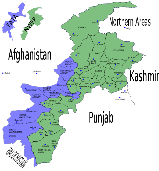
File:NWFP FATA.svg
Appearance

Size of this PNG preview of this SVG file: 558 × 600 pixels. Other resolutions: 223 × 240 pixels | 446 × 480 pixels | 714 × 768 pixels | 953 × 1,024 pixels | 1,905 × 2,048 pixels | 1,000 × 1,075 pixels.
Original file (SVG file, nominally 1,000 × 1,075 pixels, file size: 171 KB)
File history
Click on a date/time to view the file as it appeared at that time.
| Date/Time | Thumbnail | Dimensions | User | Comment | |
|---|---|---|---|---|---|
| current | 11:04, 11 August 2015 |  | 1,000 × 1,075 (171 KB) | Colajmal | issue with format |
| 11:03, 11 August 2015 |  | 1,000 × 1,120 (66 KB) | Colajmal | Map of KPK & FATA with ethnic breakdown | |
| 21:31, 6 June 2007 |  | 1,000 × 1,075 (171 KB) | Pahari Sahib | {{Information |Description=Map showing the districts of the Federally Administered Tribal Areas (FATA) FATA and the North-West Frontier Province (NWFP) of Pakistan. |Source= Self made using Inkscapte - Based on maps from http://www.nwfp.gov.pk |Date=0 |
File usage
There are no pages that use this file.
Global file usage
The following other wikis use this file:
- Usage on ar.wikipedia.org
- Usage on azb.wikipedia.org
- Usage on be-tarask.wikipedia.org
- Usage on be.wikipedia.org
- Usage on ca.wikipedia.org
- Usage on cy.wikipedia.org
- Usage on da.wikipedia.org
- Usage on en.wikipedia.org
- Usage on en.wikinews.org
- Usage on eo.wikipedia.org
- Usage on es.wikipedia.org
- Usage on fa.wikipedia.org
- Usage on fi.wikipedia.org
- Usage on fr.wikipedia.org
- Usage on hi.wikipedia.org
- Usage on hu.wikipedia.org
- Usage on hy.wikipedia.org
- Usage on id.wikipedia.org
- Usage on it.wikipedia.org
- Usage on ja.wikipedia.org
- Usage on ko.wikipedia.org
- Usage on ms.wikipedia.org
- Usage on new.wikipedia.org
- Usage on nl.wikipedia.org
- Usage on no.wikipedia.org
- Usage on pa.wikipedia.org
- Usage on pl.wikipedia.org
View more global usage of this file.

