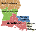
File:Louisiana regions map.svg
Appearance

Size of this PNG preview of this SVG file: 666 × 599 pixels. Other resolutions: 267 × 240 pixels | 534 × 480 pixels | 854 × 768 pixels | 1,138 × 1,024 pixels | 2,276 × 2,048 pixels | 5,018 × 4,515 pixels.
Original file (SVG file, nominally 5,018 × 4,515 pixels, file size: 557 KB)
File history
Click on a date/time to view the file as it appeared at that time.
| Date/Time | Thumbnail | Dimensions | User | Comment | |
|---|---|---|---|---|---|
| current | 09:09, 22 December 2006 |  | 5,018 × 4,515 (557 KB) | Interiot~commonswiki | rm stroke from small islands so they're not so invisible |
| 20:47, 21 December 2006 |  | 5,018 × 4,515 (557 KB) | Interiot~commonswiki | rearrange colors again | |
| 20:36, 21 December 2006 |  | 5,018 × 4,515 (557 KB) | Interiot~commonswiki | rearrange colors again | |
| 20:30, 21 December 2006 |  | 5,018 × 4,515 (535 KB) | Interiot~commonswiki | change around the green and the off-gray | |
| 20:18, 21 December 2006 |  | 5,018 × 4,515 (498 KB) | Interiot~commonswiki | {{SVG}} {{Information |Description=Map over Louisiana's regions |Source=Based on Image:Map of Louisiana highlighting Jefferson Davis Parish.svg, colors filled in based on data from [http://ccet.louisiana.edu/03a_Cultural_Tourism_Files/01.00_The_Land. |
File usage
The following 4 pages use this file:
Global file usage
The following other wikis use this file:
- Usage on ar.wikipedia.org
- Usage on cy.wikipedia.org
- Usage on da.wikipedia.org
- Usage on en.wikipedia.org
- Usage on fi.wikipedia.org
- Usage on fr.wikipedia.org
- Usage on gl.wikipedia.org
- Usage on gu.wikipedia.org
- Usage on hu.wikipedia.org
- Usage on it.wikipedia.org
- Usage on ja.wikipedia.org
- Usage on kn.wikipedia.org
- Usage on pl.wikipedia.org
- Usage on pt.wikipedia.org
- Usage on ro.wikipedia.org
- Usage on simple.wikipedia.org
- Usage on vi.wikipedia.org
- Usage on zh.wikipedia.org
