
File:Bathymetric map of the Baltic Sea-fi.svg

Size of this PNG preview of this SVG file: 498 × 600 pixels. Other resolutions: 199 × 240 pixels | 398 × 480 pixels | 637 × 768 pixels | 850 × 1,024 pixels | 1,700 × 2,048 pixels | 684 × 824 pixels.
Original file (SVG file, nominally 684 × 824 pixels, file size: 2.82 MB)
This is a file from the Wikimedia Commons. Information from its description page there is shown below.
Commons is a freely licensed media file repository. You can help. |
| Description |
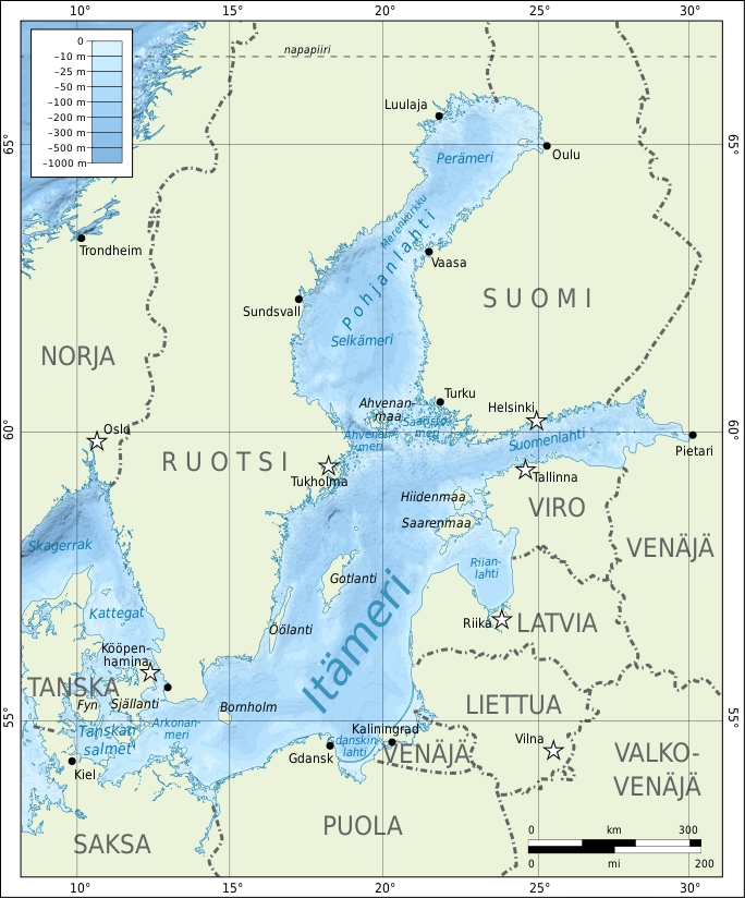
English: Bathymetric map of the Baltic Sea. Suomi: Itämeren kartta. |
| Date | |
| Source | Self-made in Inkscape. Bathymetry and shoreline from STRM30_PLUS; names of gulfs and parts of the sea from http://www.itameriportaali.fi/fi/tietoa/sanakirja/fi_FI/itameren_osat/ |
| Author | Mysid |
I, the copyright holder of this work, hereby publish it under the following license:
This file is licensed under the Creative Commons Attribution-Share Alike 3.0 Unported license.
- You are free:
- to share – to copy, distribute and transmit the work
- to remix – to adapt the work
- Under the following conditions:
- attribution – You must give appropriate credit, provide a link to the license, and indicate if changes were made. You may do so in any reasonable manner, but not in any way that suggests the licensor endorses you or your use.
- share alike – If you remix, transform, or build upon the material, you must distribute your contributions under the same or compatible license as the original.
Original upload log
This image is a derivative work of the following images:
- File:Bathymetric_map_of_the_Baltic_Sea-en.svg licensed with Cc-by-sa-3.0, Cc-by-sa-3.0/en
- 2008-05-30T16:49:04Z Mysid 688x845 (835105 Bytes) {{Information |Description={{en|1=Bathymetric map of the [[w:Baltic Sea|]].}} {{fi|1=[[:fi:Itämeri|Itämeren]] kartta.}} |Source=Self-made in Inkscape.Boundaries, roads, and place names based on a public domain CIA map (http
Uploaded with derivativeFX
File history
Click on a date/time to view the file as it appeared at that time.
| Date/Time | Thumbnail | Dimensions | User | Comment | |
|---|---|---|---|---|---|
| current | 16:51, 23 April 2019 | | 684 × 824 (2.82 MB) | Opetustuubi | Uusi yritys: Suurempi Itämeri-teksti. |
| 16:50, 23 April 2019 |  | 684 × 824 (2.82 MB) | Opetustuubi | Reverted to version as of 21:06, 2 September 2010 (UTC) | |
| 16:49, 23 April 2019 |  | 684 × 824 (2.82 MB) | Opetustuubi | Äskeisessä latauksessa teksti ei jostain syystä näkynyt. | |
| 16:41, 23 April 2019 |  | 684 × 824 (2.82 MB) | Opetustuubi | Muutin Itämeri-tekstin vähän suuremmaksi, jotta erottuu paremmin. | |
| 21:06, 2 September 2010 |  | 684 × 824 (2.82 MB) | Mysid | bugfix | |
| 20:59, 2 September 2010 |  | 650 × 787 (4.07 MB) | Mysid | complete remake from new sources | |
| 21:51, 13 January 2009 |  | 688 × 845 (804 KB) | Neurovelho | fixed typo: Gdánsk -> Gdańsk | |
| 19:02, 13 January 2009 |  | 688 × 845 (804 KB) | Neurovelho | {{Information |Description={{en|1=Bathymetric map of the Baltic Sea.}} {{fi|1=Itämeren kartta.}} |Source=*File:Bathymetric_map_of_the_Baltic_Sea-en.svg |Date=2009-01-13 17:35 (UTC) |Author=*derivative work: ~~~ *[[ |
File usage
The following page uses this file:
Global file usage
The following other wikis use this file:
- Usage on fi.wikipedia.org
- Usage on fi.wikibooks.org